Base map and road classes
The INVIA Base Map: Forest Service, BLM, NPS and state OHV data unified and drawn in six vehicle-access classes, what feeds it, difficulty casings, the legend, and what is Pro.
Last checked against the live app on 3 September 2026.
INVIA draws every dirt road as what it is, so one look at a line tells you whether it is single track, an ATV-width trail, open to everything, or pavement-legal only. Forest Service, BLM, National Park and state OHV data are unified into one layer, and every road in that layer falls into one of six vehicle-access classes. You read one map instead of four agency maps side by side.
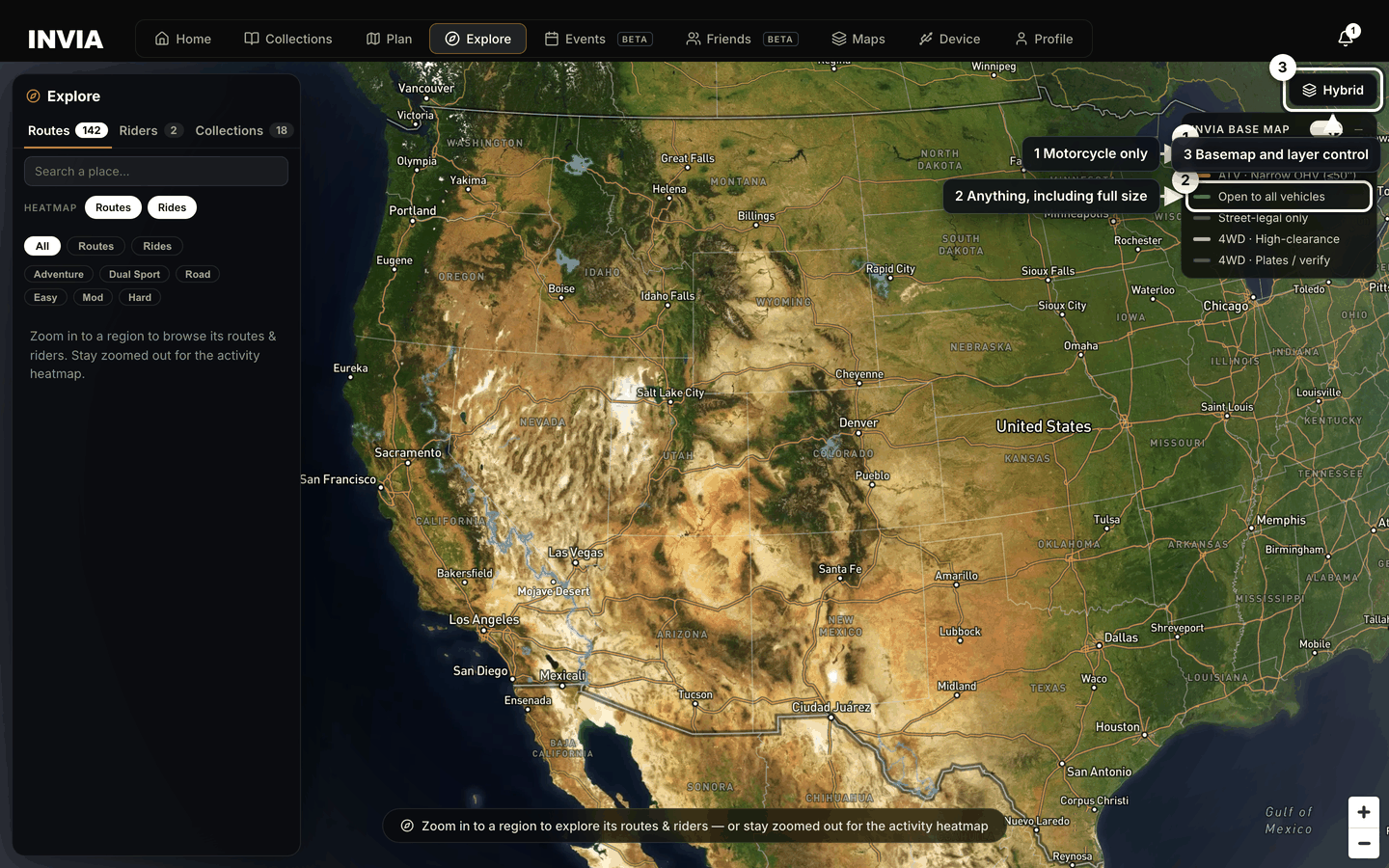
- Motorcycle only
- Anything, including full size
- Basemap and layer control
The six classes#
A class names the vehicles allowed on the road, which is the question that decides whether you can ride it. Surface and difficulty come after that.
| Class | What it means |
|---|---|
| Single Track | Motorcycle-only trail. |
| ATV · Narrow OHV (≤50″) | Trails limited to narrow OHVs: dirt bikes and ATVs, not side-by-sides. |
| Open to all vehicles | Any vehicle, including full-size 4x4 and side-by-sides. |
| Street-legal only | Highway-legal vehicles only. Plated bikes yes, unplated no. |
| 4WD · High-clearance | Technical four-wheel-drive routes. |
| 4WD · Plates / verify | 4WD routes with a plate requirement or a designation to confirm locally. |
State OHV trails carry a difficulty casing as well as a class, because a trail you are allowed to ride can still be harder than you want it to be:
- Rated difficult: a dark casing and one diamond after the name.
- Rated extreme: a black casing and two diamonds after the name.
Turning a class off#
Each class row is a switch, so you can strip the map down to the roads you can legally ride and stop reading lines that do not apply to your bike. Turn one off and every road of that class stops being drawn across every source at once, rather than only in the agency data you happen to be looking at.
What you see:
- No lines of that class anywhere on the map.
- No labels for roads of that class are drawn.
- The class row in the legend is unchecked.
- The class count in the Layers control drops by one, from 6/6 to 5/6 and on down to 0/6 once all six are off.
What still works:
- Every class you left on draws as before.
- Nothing is deleted, because the roads stay in the INVIA Base Map data and draw again as soon as you switch the class back on.
- Tap to identify still works on the classes that are on.
What to do:
- Open the legend card or the Layers control.
- Switch the class back on. Its lines and labels draw again.
The master switch turns the whole INVIA Base Map off in one press, which is the quickest way to see the basemap underneath without agency lines over it. Turning every class off empties the map the same way, and the count then reads 0/6 rather than off. The count is how many of the six classes are drawn, so only the master switch makes it read off.
Ride-area and trail pins stay on the map either way, because the Pins section is separate from the base map, so you keep your reference points while the road lines are off. Press the master switch again and every class you left on comes back.
What feeds it#
The layer is assembled from these sources, and where an entry tells you to verify locally, treat the line as a plan rather than as permission.
- USFS MVUM, the designated routes for every National Forest. The printed Motor Vehicle Use Map remains the legally binding document, so use the INVIA line to plan and the printed map to settle a question.
- Extra FS Roads: Forest Service system roads that the MVUM never mapped, so verify locally before you trust them.
- BLM Roads & Trails, the motorized network on Bureau of Land Management ground.
- NPS Backcountry Roads, unpaved park roads, street-legal vehicles only.
- State OHV Trails for California, Michigan, Minnesota, Oregon, Colorado and Utah.
- Named Trails (OSM) from OpenStreetMap, with difficulty where it is known, which is why one trail carries a rating and the next one carries none.
- Land Boundaries: Wilderness (closed to all motor vehicles), military land (restricted, do not enter), and National Forest administrative boundaries.
Every source prints its own names, so the name you read on a line comes from the agency that mapped it. MVUM roads and trails, BLM roads, Park Service roads, state OHV trails, Named Trails and Extra FS roads all carry a name label, and so do Wilderness and military land. Only BLM trails go unlabelled, because BLM names come from its roads alone. Names arrive at different zooms, so a name missing at a wide view appears as you come in. Wilderness and military names start at about zoom 8 and named OSM trails at about zoom 10. MVUM, Park Service and state OHV names start at about zoom 12, and BLM and Extra FS road names at about zoom 13.
The legend card#
The INVIA Base Map legend card sits on the map and is both the key and the switch, so you can read a line and change what is drawn without leaving the map. It holds a master switch, a Hide legend control, and one row per class.
Press Hide legend when the card covers ground you are trying to read, and the card collapses to a Base Map pill.
What you see:
- A small Base Map pill where the legend card was.
What still works:
- Every road class you left on is still drawn.
- Every switch keeps the setting it had.
What to do:
- Press the Base Map pill to open the legend card again.
The Layers control#
The Layers control holds the same class switches as the legend card plus the pins and the extra overlays, so it is the one place where you can see everything that is drawn.
| Section | What it holds |
|---|---|
| INVIA Base Map | The six classes, with a count of how many are drawn out of six: 6/6, 4/6, 0/6, or off when the master switch is off. |
| Pins | Ride areas, Trail pins. |
| Info | Land boundaries, Road labels, and Extra FS roads when unlocked. |
Your choices persist in the browser and carry between the builder and Explore, so the map you set up for planning is the map you get when you start building a route.
Defaults:
| Setting | Default |
|---|---|
| Base map | On |
| Every class | On |
| Pins | On |
| Land boundaries | Off |
| Road labels | On |
| Legend | Shown |
Land boundaries start off so the road lines stay readable. Switch Land boundaries on in the Info section when you are planning near a Wilderness or military edge and need to see where that edge runs.
Road labels turns every name off together, which includes the italic Wilderness and military land names and not only the road numbers. Switch it off when the names crowd the lines and you want to read the shape of the network instead.
Tap any road#
- Open Explore, or the builder's Explore mode.
- Tap a road.
The whole route highlights and a card opens, so you can see how far the road runs before you read anything about it. The card lists:
- The road number.
- Its class.
- The surface.
- The designation.
- The dates it is open, or a pointer to the agency for seasonal closures.
- The managing agency.
- Difficulty.
- One-way direction where it applies.
What is Pro on the map#
Everything you need to read the map is on every account, so a free account gives you a working map rather than a sample. Pro adds the two narrowest road classes, two overlays and your own heat map.
Pro:
- The Single Track class.
- The ATV class.
- Land boundaries.
- Extra FS roads.
- Your personal heat map.
On every account:
- The other four road classes.
- All seven basemaps.
- Every pin.
- Tap to identify.
- The community heat map.
A locked class on a free account#
What you see:
- The class stays in the legend, dimmed, with a lock.
- No lines of that class are drawn on the map.
- Tapping the locked class says {class} is a Pro feature.
- The class count starts at 4/6, because the two Pro classes are never counted on a Free account.
- The Extra FS roads switch is listed in Info only when it is unlocked.
What still works:
- The four unlocked road classes draw as normal.
- A locked trail pin still opens its card, because pins and road lines are separate layers. The card reads {class} lines are not drawn on the Free map. Pro draws them.
- Every basemap, every pin and tap to identify.
What to do:
- Upgrade to Pro to draw the locked classes. Plans.
- The Extra FS roads switch appears in Info as soon as you upgrade, so there is nothing to turn on beforehand.